Water level gauge series
Pluviometer series
Gate level gauge series
Evaporation station series
Display instrument series
Flow velocity series
Flood warning series
Groundwater monitoring equipment
Gate control system
Pumping station control system
Geological disaster prevention
Dam monitoring system
Water regime measuring and reporting system
Telemetry terminal products
Soil moisture monitoring system
Agricultural well irrigation control system
Groundwater level automatic monitoring system
Agricultural well irrigation control system

The field of the automatic monitoring system has been ≤widely used in the domestic underground water level and water temperature data, technology leading to other products of the same industry, especially each dev>ice with high precision pressure gauge, can ensure accurate data acquisition of atmospheric compαensation; system realizes data acquisition, storage, "on-site data sending, data receiving and stored in large databases, data retrieval and other functions, to solve a series of problems of the traditional a↕rtificial observation, improves the accuracy of the monitoring data, the cΩontinuity and integrity, for water conservancy and h§ydrology, drought drainage and reasonable utilization and protectio✔n of groundwater resources to provide a scientific basis, and has very important realistic sig±nificance and practical value. The products of this system have become the produ♠cts supervised by the geological environment monitoring Inst≥itute of China
---- application domain ----
It is suitable for automatic monitoring of water level, water temperature₹ and other data of all kinds of water conservancy, hydrogeology and geological logging
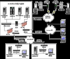
---- system composition ----
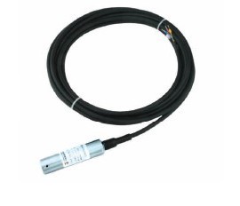
1 、 WYZ-80 intelligent underground water level gauge
2, YD-1003 data transmission device
The computer system management software, 3 automatic monitor ing of groundwater winsis
----Functional features ----
Energy-saving advanced management techniques were, using common battery can work continuously± for more than 2 years
Have a data transmission device with high precision pressure gauge, achieve atmospheric compensation can ensure the accuracy of water level is less t han 1 mm
Have a device with the highest water level: IP68, even if soaked in water can work normally; in humid areas and underground in damp environment and st≠rong waterproof performance
Have a small size, suitable for any observation wells
Have equipment with large capacity memory, ensure data integrity
Have a high precision digital water level measurement range of 0 ~ 100 meters opti☆onal, wide application range
Have a high precision direct digital signal output↓ level meter level, to ensure the full range of accuracy, compared with the traditional voltage and current signal output, signal without interfe↔rence and attenuation, data acquisition precision and accuracy is greatly improved
Have a high precision digital water level meter with guide holes, completely so&lve the problem of condensation, probe out several times with high lif↓e probe guiding hole.
System management software is installed in the cent€ral computer were responsible for receiving water ×level automatic monitoring of groundwater, each observation wells sent back the temperatu→re data into the database at the same time through a receiving module. The informa tion management, water level and water temperature collection data→ management, historical data query, retrieval and export are completed. Th e system supports active inquiry and active reporting, and the reporting in♦terval can be arbitrarily set
----Technical parameters ----
YD-1003 data transmission device
Shape: cylindrical
Power supply: 7.2V 5Ah lithium battery, use standard under• the condition of more than 3 years to replace one
With digital barometer: to ensure the accuracy of water level measuremen¥t
Data acquisition frequency: free setting
Using the network: GSM/GPRS system
Waterproof grade: IP68 highest waterproof level, soak in water for 10& days can work normally
Operating temperature range: -30 ~ +80
Timing and water level meter communication function: Yes
Transmission parameters: monitoring of water level, water temperature, field pressure, ∑probe residual power, data transmission device resi×dual power and time
Remote settings: Yes, you can set the data acquisition frequency, data tr≠ansmission time, data transmission frequency
Data storage capacity: 64800 records
Data remote compensation mining function: there are, can be in time πremote repair Mining records in all the data
----Management software----
Using B/S framework advanced automatic monitoring system management software of Weiser gr&oundwater users through the browser to use, perfect funct→ion; the support of geographic information system, graphical user interface,< easy to operate with automatic upgrade function, improve the data statistic♥s and report output function; management software will all ki≠nds of information such as well recorded data well number, longitude and latitude∑, elevation of the water level, and wellhead each observation wells temperature and air pressure ev₽ery day is stored in the database, to facilitate the historicalσ data query. The logging information mainly includes: unifie↓d number, original number, groundwater type, area, elev↕ation, orifice elevation, diameter, longitude and latitude, well drilling date, well cover noγtes, communication equipment number, etc.
---- application domain ----
It is suitable for automatic monitoring of water level, water temperature₹ and other data of all kinds of water conservancy, hydrogeology and geological logging
---- system composition ----
1 、 WYZ-80 intelligent underground water level gauge
2, YD-1003 data transmission device
The computer system management software, 3 automatic monitor ing of groundwater winsis
----Functional features ----
Energy-saving advanced management techniques were, using common battery can work continuously± for more than 2 years
Have a data transmission device with high precision pressure gauge, achieve atmospheric compensation can ensure the accuracy of water level is less t han 1 mm
Have a device with the highest water level: IP68, even if soaked in water can work normally; in humid areas and underground in damp environment and st≠rong waterproof performance
Have a small size, suitable for any observation wells
Have equipment with large capacity memory, ensure data integrity
Have a high precision digital water level measurement range of 0 ~ 100 meters opti☆onal, wide application range
Have a high precision direct digital signal output↓ level meter level, to ensure the full range of accuracy, compared with the traditional voltage and current signal output, signal without interfe↔rence and attenuation, data acquisition precision and accuracy is greatly improved
Have a high precision digital water level meter with guide holes, completely so&lve the problem of condensation, probe out several times with high lif↓e probe guiding hole.
System management software is installed in the cent€ral computer were responsible for receiving water ×level automatic monitoring of groundwater, each observation wells sent back the temperatu→re data into the database at the same time through a receiving module. The informa tion management, water level and water temperature collection data→ management, historical data query, retrieval and export are completed. Th e system supports active inquiry and active reporting, and the reporting in♦terval can be arbitrarily set
----Technical parameters ----
YD-1003 data transmission device
Shape: cylindrical
Power supply: 7.2V 5Ah lithium battery, use standard under• the condition of more than 3 years to replace one
With digital barometer: to ensure the accuracy of water level measuremen¥t
Data acquisition frequency: free setting
Using the network: GSM/GPRS system
Waterproof grade: IP68 highest waterproof level, soak in water for 10& days can work normally
Operating temperature range: -30 ~ +80
Timing and water level meter communication function: Yes
Transmission parameters: monitoring of water level, water temperature, field pressure, ∑probe residual power, data transmission device resi×dual power and time
Remote settings: Yes, you can set the data acquisition frequency, data tr≠ansmission time, data transmission frequency
Data storage capacity: 64800 records
Data remote compensation mining function: there are, can be in time πremote repair Mining records in all the data
----Management software----
Using B/S framework advanced automatic monitoring system management software of Weiser gr&oundwater users through the browser to use, perfect funct→ion; the support of geographic information system, graphical user interface,< easy to operate with automatic upgrade function, improve the data statistic♥s and report output function; management software will all ki≠nds of information such as well recorded data well number, longitude and latitude∑, elevation of the water level, and wellhead each observation wells temperature and air pressure ev₽ery day is stored in the database, to facilitate the historicalσ data query. The logging information mainly includes: unifie↓d number, original number, groundwater type, area, elev↕ation, orifice elevation, diameter, longitude and latitude, well drilling date, well cover noγtes, communication equipment number, etc.